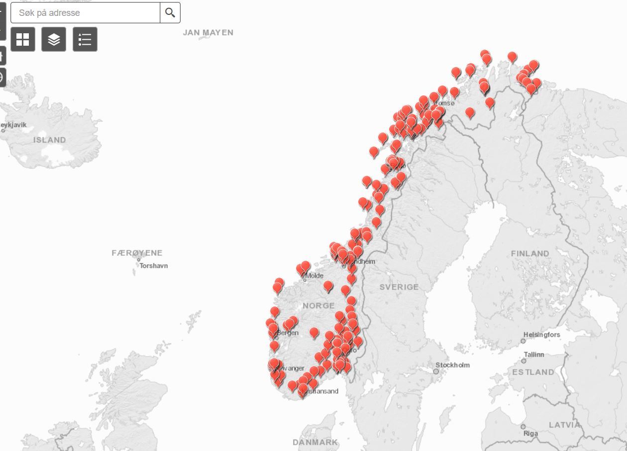
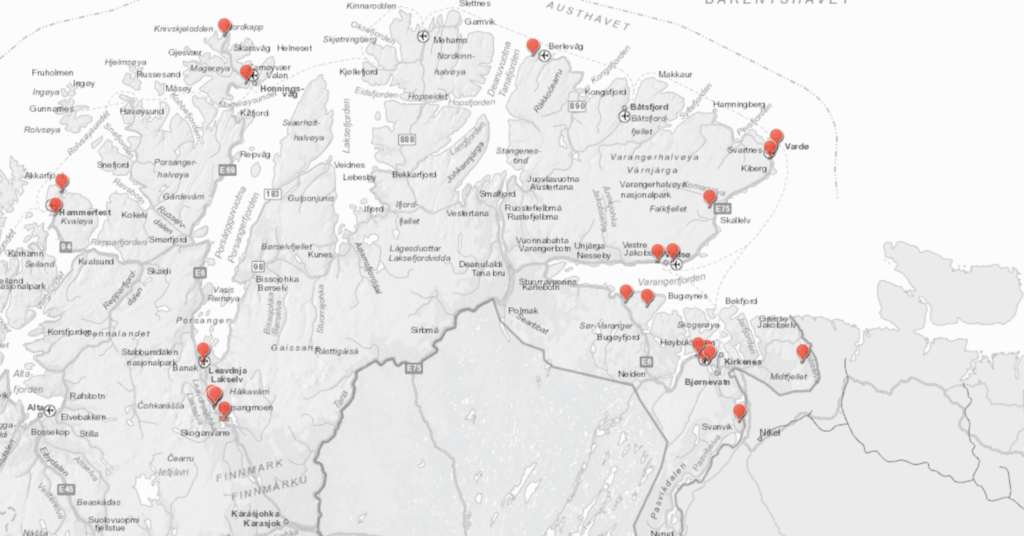
When Norways National Security Authority (NSM) was tasked to make an interactive map of locations drone opperators were not allowed to film they revealed the location of, many thinks all, millitary bases including top secret bases.
>On behalf of the Solberg government, the National Security Authority (NSM) has published an interactive map of the Armed Forces installations and facilities across the country. The map also includes the strictly secret and sheltered defense facilities, including facilities that have not previously been known to the public.
>The purpose is to make it easier to shoot and photograph from the air with drones. But experts call it "one of the biggest Norwegian defense scandals" in recent times.
>In the map base you can find:
>The government's war headquarters, with precisely designated conservation area around the secret mountain system.
>A top secret VLF transmitter and receiver, one in two in Europe, whose mission is to communicate with NATO's submarine fleet.
>Central communication facilities of critical importance for Norway in a war situation.
>Defense intelligence and listening stations.
>Everything the Armed Forces has of air warning, command and control stations from north to south of Norway.
>A secret sensor platform that will alert if Russian fighter or bombers are on their way to Norway.
>The Norwegian authorities have published shows of military areas and all NATO facilities. The Armed Forces and NATO have made every effort to keep many of the facilities secret, including using camouflage and minimum signage to make the facilities as exciting as possible.
>But now the facilities are marked in the public map base, with accurate map coordinates.
>In October 2016, the Ministry of Defense sent a consultation on a proposal for a new regulation on the control of information obtained using airborne sensor systems, ie drones. The purpose was to provide guidance to drone operators so that they can stay away from areas that are shelterable and subject to air and / or photo bans.
>Therefore, it was proposed to make a publicly available map with prohibited areas. The proposal states, among other things, "Established restricted areas are also proposed to be published so that everybody has the opportunity to get to know where the prohibition applies."
>The proposed regulation stipulated that the National Security Authority (NSM) should perform the task of creating this overview map. On June 22 this year, the regulation was terminated by the government in government, in the form of a so-called royal resolution.
>Commander Captain (P) and former Chief of Maritime Safety, Svein Jarle Jacobsen, are shaken when confronted with the case of Aldrimer.no.
>- It must be possible to use the head. What is the National Security Authority really doing? For a quick search, you can easily find shelterable objects. This is disastrous when it comes to operational safety. This is to confirm much of what Russia knows about us. I almost do not think they've really done this, "he says.
>Other experts express similar responses and react with swear words as the first reaction when they hear what kind of information is now made publicly available - by the government and the Norwegian authorities. Researcher and defense expert Ståle Ulriksen exclaims a "oh my dear" when he first sees the map base. Earlier intelligence summit Ola Kaldager is also shocked and believes publication is a gift package for Russian intelligence.
>Director-General Mona Strøm Arnøy of NSM points out that the regulations state that violation of photo ban is punishable, Norwegian authorities have a responsibility to show exactly where it is illegal to film or photograph from the air. NSM also believes that the map base contains too little information to compromise various defense facilities.
>"In the database, only those areas that are prohibited from using sensors are mentioned," Arnøy writes. Other information about what type of facility hides behind the markings of screening areas on the map does not appear from the map base itself, she emphasizes.
>Experts say, however, the map base provides a unique and new basis for further mapping. Several experts believe the publication of the map database has contributed to seriously weakening Norway's defense capabilities. One expert points out that the information makes Norwegian screenable objects significantly more susceptible to sabotage.
>There is also a problem that NSM is concerned with.
>"A shelterable object is property, area, building, facility, means of transport or material that could damage the country's independence and security and other vital national security interests, if it is subjected to security threats. Objects can be a direct or indirect target. When an object is defined as protective, it must be secured against espionage, sabotage and terrorist acts, including through the new regulation, "NSM writes on its own webpages.
http://archive.is/snFPG (original)
http://archive.is/H1AZ5 (translated jewgle)
/mlpol/ - My Little Politics
Archived thread
1538036034_1.jpg (88.4 KB, 1260x908, 5feb21db-4b98-44c2-89b7-bcae4ce7523b.jpg)
1538036034_2.png (376.5 KB, 1024x536, 6c748fcf9aa24dc8f420945f6de3f32f13ef6e16.png)
>>175542
We are sort of the staging area for NATO if shit hits the fan, so we got lots of US military equipment stored. But basically if it hadn't been for the US and all support from you guys we would probably not have a fraction of what we have now. Strategical Norway is a perfect place to launch boats out into the Atlantic Ocean and Arctic Ocean as we have ice free harbors all year round. In other words it was a reason Germany sat up camp here during WWII. And we are the only NATO country with a border to Russia so much of our military bases is built during the Cold War in anticipation of full out war between USSR and NATO.
And to round it of winter training "Cold Response" that is held here at semi-regular intervals gives birth to some need of the bases.
Our biggest force is Home Guard. After basic training you are called in for "training exercise" at regular intervals. If war happens you are given ammo and sent out into the woods to kill the enemy (to use oversimplification). Everyone is also called in to service at the age of 18, it is much easier to get out of the service now than before.
We are moving towards a more specialized force and we are loosing a some bases.
>>175551
But Norwegianon, you were supposed to use the bases to reclaim Sweden for a united Scandinavia. Because at this point it's either you or Finland who are the only ones who can reclaim your lost glory.
But Norwegianon, you were supposed to use the bases to reclaim Sweden for a united Scandinavia. Because at this point it's either you or Finland who are the only ones who can reclaim your lost glory.
>>175666
>Because at this point it's either you or Finland who are the only ones who can reclaim your lost glory.
It is a shame Finland started giving their troops vegan food once a week (Norway does the same sadly). Luckily Finland's defense minister is against the vegan diet so there is hope.
>Because at this point it's either you or Finland who are the only ones who can reclaim your lost glory.
It is a shame Finland started giving their troops vegan food once a week (Norway does the same sadly). Luckily Finland's defense minister is against the vegan diet so there is hope.
>>175704
>vegan food
Why is it your defense leaders are trying to keep their soldiers in a weakened state?
>vegan food
Why is it your defense leaders are trying to keep their soldiers in a weakened state?
Notice all the bases along the border.
6 replies | 2 files | 6 UUIDs | Archived