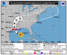
>Hurricane Laura
7:00 PM CDT Tue Aug 25
Location: 25.0°N 89.0°W
Moving: WNW at 17 mph
Min pressure: 983 mb
Max sustained: 85 mph
>Quick Rundown
The storm is quickly intensifying and will possibly reach category 4 status before landfall in either west Louisiana, East Texas, or both.
>Stats and visuals
https://weather.cod.edu/satrad/
https://www.star.nesdis.noaa.gov/GOES/index.php
https://www.nrlmry.navy.mil/TC.html
https://realearth.ssec.wisc.edu/?products=MIMICTPW2E.100&×pan=-30t&animationspeed=100&animate=true
>Info and Data
www.nhc.noaa.gov
www.ndbc.noaa.gov
>Models
https://www.tropicaltidbits.com/analysis/models/
http://spaghettimodels.com/
https://www.ventusky.com/
storm.aoml.noaa.gov
>Model Run Times (EDT)
GFS
00z = 10:30pm
06z = 4:30am
12z = 10:30am
18z = 4:30pm
NAM
00z = 8:35pm
06z = 2:35am
12z = 8:35am
18z = 2:35pm
ICON
00z = 11:00pm
06z = 5:00am
12z = 11:00am
18z = 5:00pm
UKMET
00z = 2:00am
12z = 2:00pm
ECMWF (sooner if you go directly to their site)
00z = 2:00am
12z = 2:00pm
>Twitter Feeds
https://twitter.com/TropicalTidbits
https://twitter.com/NHC_Atlantic
https://twitter.com/Jeff_Piotrowski
https://twitter.com/RyanMaue
https://twitter.com/hurricanetrack
https://twitter.com/NWS
https://twitter.com/OSUWXGUY
>Preparations and Safety
https://www.redcross.org/get-help/how-to-prepare-for-emergencies/types-of-emergencies/hurricane.html
https://www.ready.gov/hurricanes
https://www.weather.gov/safety/hurricane
Mandatory Evacuations: Galveston, TX
Orange, TX
Jefferson, TX (south of Texas 73)
Calcasieu, LA
Cameron, LA
/mlpol/ - My Little Politics
Archived thread
>>281166
You better get out of there, ore else you and everyone you know are dead. And your kids die too.
You better get out of there, ore else you and everyone you know are dead. And your kids die too.
The storm could be a a cat 5 by the time it reaches land. If any of you are still in its path then get the hell out of there.
Some dumbass is livestreaming his trip to Beaumont. Https://www.youtube.com/watch?v=akWLQBREfaw
https://mobile.twitter.com/AaronRigsbyOSC/status/1298958316148846592?ref_src=twsrc%5Etfw%7Ctwcamp%5Etweetembed%7Ctwterm%5E1298958316148846592%7Ctwgr%5E&ref_url=https%3A%2F%2Fd-8409404711595009730.ampproject.net%2F2007302351001%2Fframe.html
Louisiana and Texas coastlines got fucked pretty hard but east texas is pretty mild. It got heavy winds and downpour through the night, but it's no worse now than an ordinary storm
Louisiana and Texas coastlines got fucked pretty hard but east texas is pretty mild. It got heavy winds and downpour through the night, but it's no worse now than an ordinary storm
>>281301
You have a drone? I live in Orange near the community college. I want to see how bad that area got fucked up.
You have a drone? I live in Orange near the community college. I want to see how bad that area got fucked up.
>>281166
>>281236
>>281292
Why do you choose to live where you do? Isn't it daunting to know that at any moments notice a hurricane might roll into your neighbourhood and grab your house, your car, your wife, your dog and everything you've ever worked for in life and just fly away into the sunset with it? What makes you stay?
>>281322
Because there are a lot of chemical plants in the area. The cost of living is low and the petrochemical plants pay high salaries.
Because there are a lot of chemical plants in the area. The cost of living is low and the petrochemical plants pay high salaries.
There are many reasons to live out here. The first is that living right on the water means that there is a constant breeze, which really helps to cool down in a place where the temperature hovers between 80 and 100 F almost the entire year. The view of the Sun rising over the water in the morning is incredible, especially on calmer mornings, and you can watch the fishing trawlers as they move along. Besides that, my family used to own jet skis and a small sail boat. We would sail out into the water. More recently, we can use our backyard as a sort of gun range, shooting towards or into the water with AR15s, AKs, M1s or what have you. We're like 20 or more feet above sea level, so while any Hurricane could be one to actually threaten our home, very few actually are dangerous, as the Hurricane has to both be an exceedingly powerful one, and hit in a precise location to the west of us in order to actually threaten us. If anything, living directly by the water is safer in some ways, because it means we don't have to worry about flooding.
>>281980
All of that is overshadowed by the fact that this part of the country is filled with niggers and beaners.
All of that is overshadowed by the fact that this part of the country is filled with niggers and beaners.
>>281991
You'd be amazed by how much the community make up varies by driving a few miles. Some areas are fairly black, some are Hispanic, but many are very white.
You'd be amazed by how much the community make up varies by driving a few miles. Some areas are fairly black, some are Hispanic, but many are very white.
>>282188
I am aware that there are isolated white communities (mostly in the rural areas), but this part of the country is pretty much lost to muds. There isn't a future here. Whites are a minority in all of the major cities (Beaumont, Houston, Lake Charles, Galveston, Port Arthur, ect).
I am aware that there are isolated white communities (mostly in the rural areas), but this part of the country is pretty much lost to muds. There isn't a future here. Whites are a minority in all of the major cities (Beaumont, Houston, Lake Charles, Galveston, Port Arthur, ect).
22 replies | 2 files | 11 UUIDs | Archived

 Ex: Type :littlepip: to add Littlepip
  Ex: Type :eqg-rarity: to add EqG Rarity